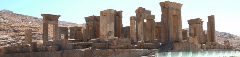
THE AQUEMENID ROYAL ROAD IN CENTRAL ASIA
Text by Joaquín Velázquez Muñoz
Article published in Revista Arqueología 2011, Año nº 32 Nº 359
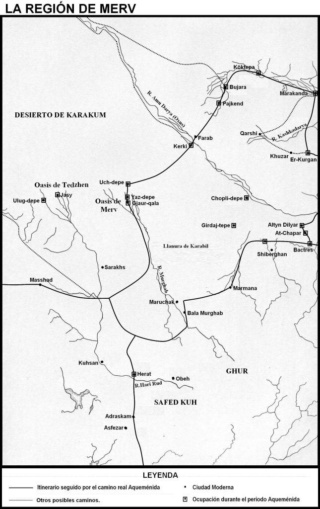
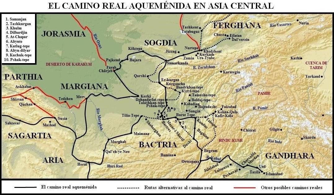
The Achaemenid royal road was also projected in the northernmost regions of the Persian empire, that is, in Margina, Khorasmia, Bactria and Sogdiana. From Herat, in the Aryan satrapy, the road headed north to the oasis of Merv, from where, after crossing the desert, the Oxus river and the Polytimetos valley, it reached Bukhara, Marakanda (Samarkand) and the Yaxartes River, thus connecting the road through the Turkestan steppe with the routes that led to China, where objects adorned with horned lion protomes have been found in both Xinjang and Xinyuan, a theme Aqueménida itself (see the maps attached to this article: “The Merv region” and “Bactria and Sogdiana”).
Merv was the provincial capital of Margiana, and is well recognized for its defences on the Erk-kala site and on Gjaur-kala, where in addition, in the former, an important number of cylindrical-conical vessels have been found, which according to the Russian excavators are an indicator of occupation during the Achaemenid period. At Erk-kala, levels of occupation dating from the Yaz II-III periods (600-400 BC) have been found, such as two platforms built with rectangular bricks. The settlement was surrounded by a wall, about 10.5 meters thick, which included a circular area of approximately 400 x 500 metres. There were other habitable areas to the south and east of the walls, thus expanding the total area of the settlement to a surface of 1800 x 500 meters. Some networks of channels that formed the Merv oasis were also identified and some fortified alignments, belonging to the Achaemenid period, were discovered to the northeast of the region, in a now desert area of the Murghab delta, in the course of surveys and survey campaigns. The Antiochus wall, which protected the heart of the oasis to the north, was never dated to the Achaemenid period, although it is possible that some sections belong to this time.
PHYSICAL EVIDENCE OF THE ROUTE
On an archaeological view, on this route, some establishments can be located where employment has been discovered during the Achaemenid period, such as Yaz-depe and Uch-depe, north of Merv. At Kerki, located on the southern bank of the Oxus River, the point where this river would be crossed over, Achaemenid darics have been found, as in Samarkand (Afrasiyab).
The road, from this point, would continue towards the northwest, via Pajkend, Bukhara, Köktepa and Samarkand. As for the Bukhara area, at an archaeological level, some sites have been found that apparently were in use during the Achaemenid period, such as Bukhara itself, Varakhsha, Kuzmantepe and Kumrabad I and II, where the pottery of these places is comparable to the repertoire of Afrasiyab and Er-kurgan. In Koktepa the presence of a large fortified site with a citadel, one or more palaces, a temple and a worship platform were observed. Excavations under way on the site by a Franco-Uzbek expedition will provide further information on what appears to be an important settlement from the Achaemenid period.
Regarding Samarkand, known as Afrasiyab, capital of the Sogdiana satrapy, it has been observed, in addition to the presence of darics, a citadel and a lower city that occupied an area of 219 hectares, and which continued inhabited during the period Achaemenid, as the ceramic remains similar to those of Yaz II-III seem to attest; Ongoing excavations by a Franco-Uzbek expedition should give us more information. The same occurs with the Nurtepa and Khodjent settlements, on the southern bank of the Yaxartes River, where the excavations should provide us with much more detailed information on the Achaemenid period in these places. At the moment, at Nurtepa, fragments of bridge-beak jars have been found very close to the Iranian forms..
In addition, a series of sites have been discovered following the upper course of the Yaxartes, such as Dal’verzin, on the southern bank, and Chust and Ejlatan on the northern bank, while Tujabguz, was located north of Khodjent, in territory that in principle it was outside the Achaemenid domain. In these sites in the Ferghana region, a first period of occupation can be observed, called Ejlatan, with agricultural sites consolidated from the VIIth-VIth century BC. to the fourth century BC, with ceramics worked and often painted differently from those of the rest of Central Asia. The continuity of these sites is observed from the IVth century BC. with the Markhamat period, with oases abundantly irrigated and with the presence of consolidated establishments as in the previous period. In any case, the absence of any clear link between the material culture of Ferghana on the one hand and the lands of the south and east, linked to each other by the ceramics of Yaz II-III on the other, excludes in principle the valley of Ferghana like an Achaemenid possession.
 THE ROUTE THROUGH THE TEXTS
In any case, we know that the Achaemenid royal road, following the narration of the historians of Alexander, reached the banks of the Yaxartes River. They also report the existence of seven cities, the largest of them, known as Cyropolis (Cira), which were subdued by Alexander in 329 BC. This site has frequently been identified with modern Ura-Tyube, although another location, Kurkath, northeast of Ura-Tyube, has also been proposed, not only because its exact location matches more closely the accounts of Greek writers, but also based on the supposition that Cyropolis could have been denominated like Kureskhata. This term probably reflects the Iranian term Kuru (š) -, ka a-, literally “the (fortified) settlement of Kuruš / Cyrus”, although it was interpreted by Greek authors as “Cira, the most distant / the last “(cf. Strabo, XI, 11.4:” Kȗra, the last city founded by Cyrus. “The Kȗra form is also mentioned by Nono of Panópolis; Geiger has suggested that this term is unlikely to be related to the Indian term Kuru ). On the other hand, there is no mention of this city in the Persian sources, although it is known that the Achaemenids paid special attention to their northeast border. For example, Darius, who in his Behistun inscription, describes the limits of his kingdom as “from the Scythians, which are beyond Sogdiana, and from there to Ethiopia” (DPh 5-6), does not make any mention of Cyropolis.
The city is defined by its citadel and by its impressive fortifications, being probably destined to the defense of the region against possible attacks by the Scythians, as indicated by Arrian (Anab., IV, 3.6; 4.8), who relates how Alexander had to cross the Yaxartes to defeat them. However so far, no archaeological find has provided any evidence to resolve this question. Mug Tepe, the citadel of Ura-Tyube, contains strata that have been dated to the IVth century BC, although the ancient site of Shirin (Š r n) at Kurkath has been only sparsely investigated to this date. Ciropolis was apparently a center of the Sogdiana region known as Ošr sana in the Middle Ages, although classical authors distinguish its inhabitants and those of neighboring peoples from the Sogdians (Arrian, Anab., IV, 1.4-5). According to the version reported by Quintus Curtius (VII, 6.17), the inhabitants of Cyropolis were called Memaceni (probably from a geographical name that is not attested, Memacene), which suggests that the old name of Ošr sana may have been Maimaka.
Another possibility is the Cureschata mentioned by Ptolemy (VI, 12.5; cf. Ammianus Marcellinus, XXIII, 6.59), a site that was not related to the Cyropolis described by the historians of Alexander. Information about Ptolemy can be traced through the itinerary of Maes Titianus, a character who is credited as having traveled along the Silk Road in the late Hellenistic period. According to Ptolemy’s data, this Cureschata was located on the bank of the Kurshab River (Korš b), one of the tributaries of the Yaxartes, where at the beginning of the Middle Ages, there was a city of Korš b on this tributary.
There was also a royal road, which from Ortospana (Kabul), via Kaukasos / Begram and Bactria, reached, after crossing the Oxus river through the Guzar and Shurab-Pardawi passes, Marakanda, a road that was used both by Bessos, in his retreat towards Nautaka, as by Alexander and his troops (See map titled “Bactria y Sogdiana”). Arrian (III, 30.4) qualifies this itinerary as “amaxitos”, that is, a path that allowed, without problems, the passage of carts, where Alexander himself drove one of these vehicles on this road. Such an indication made by Arrian indicates the existence of a royal road maintained in good condition by the Achaemenid administration.
An important point of the road, according to of Arrian’s account, was constituted by the city of Wamu, the Aomos of the Greek sources, one of the most important centres of Bactriana. In the same way, one of the Aramaic tablets found in Bactria, cites a trip made by Bessos to this city. The location of the site continues to generate various discussions. Its location is generally proposed on a mound near Tashkurgan (Khulm), on the edge of the Bactrian plain, 7 kilometers off from the mouth of the river bearing the same name.
Other sites have also been proposed, such as Altyn-Diliar Tepe, on the Balkh oasis, 35 kilometers north of Bactria. The archaeological excavations carried out on the site have revealed the important dimensions of the site, with a large central circular citadel, approximately 28 meters high, provided with a double wall with defensive circular towers. This structure is reminiscent of the platforms erected in Nad-i A and in ancient Kandahar. In addition, the site also presents two palaces that are close to the plans of the Achaemenid palaces, although that is more appropriate for the first, with colonnades, than to the second, with a courtyard and with a corridor that surrounds this central yard, and that reminds some buildings from the Bronze Age, from the Hellenistic period and the Kushans. Its location in this strategic place would allow, altoghether with the installation of a garrison, to have under control the roads that led to the two crossing points on the Oxus, Tchuchka-Guzar and Shurab-Pardawi. But when reading the text of Arrian (III, 29, 1), it is verified that the historian narrates first the capture of Aornos, then that of Bactria, and finally the march on the Oxus river, which ruins such identification, although the excavations carried out in this place confirm the importance of the Altyn-Diliar Tepe site on the royal road that went to Marakanda and to the border with the Massagetae.
The most accepted hypothesis places Warnu in a locality or in a region located in the valley of the Tashkurgan river, more specifically in the ancient city of Khulm-Tashkurgan, since the valley of this river was one of the great routes of penetration to cross the Hind kush, site through which the ancient Achaemenid road could be traced. Its strategic position within the valley allowed the city to act as a sentinel, overseeing the mouth of the Tashkurgan River on the plain and controlling the direct path that, from the west, connected Bactria with the Achaemenid Drapsaka (Kunduz), thus Warnu constituted a stage, obligatory before the crossing of a long desert steppe that preceded Drapsaka.
LIKELY ROAD LAYOUTS
Thus, it can be conjectured that the royal road, from ancient Kabul, led to Begram, from which point the road, to the west, headed for the narrow pass of Khawak, after previously crossing the Kohdaman plain, where Alexander founded the city of Alexandria of the Caucasus. The pass gave access to the Drapsaka Valley (Anderab), a region that communicates with the Surkh Kotal site, in the Kunduz Valley, through the Salang Pass. The road, from this last point, would head west through the Haibak valley and across the Bactrian plain to Bactria, via Khulm-Tashkurgan and Burat-tepe (See map titled “Bactria y Sogdiana”).
From Bactria, the road would head north, where on both the north and the northwest of the city numerous sites have been found out that presented a level of occupation during the Achaemenid period, and therefore could be located on the royal road that linked Bactria with Samarkand, including Altyn-Diliar Tepe as we have just seen. Dilbardjin, At-Chapar and Altynto can be mentioned, all southeast of Altyn-Diliar Tepe, although At-Chapar seems to be the best option for a stop on the way since it is a large and remarkable place, although smaller than Altyn -Diliar; It has a circular layout and has a wall with galleries. From this last point the road could go to Pshak-tepe after crossing the Oxus river.
The road would continue north to the fortified site of Talaskhan-tepe, in the oasis of Sherabad, a place that presents a quadrangular plan, with a wall and a citadel. From this last point, the road would continue to Dzhandavlat-tepe, a site located on the Surkhan Darya valley, and whose defenses of the lower city and the citadel are known, and which have been dated to the Achaemenid period. The itinerary could follow the course of the Surkhan Darya to the site of Kiziltepa, located on the oasis of Khalkadzhar (Mirshadin), in the vicinity of modern Shurchi. This site had an area of about 30 hectares, with a walled enclosure since the VIth century BC, although the place was occupied since the VIIIth century BC; It has also been found, in the southwest corner, an elevation of about 10 meters hight that covered an area of about 2 hectares, which could be indicating the presence of a citadel.
In any case, it is easier to think that from Dzhandavlat-tepe the road would head northwest like the modern highway does instead of making a detour through Kiziltepa (See the map titled “Bactria y Sogdiana”). In this way, Kurgancha and Er-Kurgan would be reached, although in other sites in Sogdiana, such as Kashka Darya, an occupation that goes from the Iron Age to the Kushana period has also been observed, so many other points could have been located on this royal road. Er-Kurgan, located in the southern part of Sogdiana, has strata of occupation during the Achaemenid period on a long-occupied site, with a settlement area covering about 34 · hectares. This area was surrounded by a wall during the VIth century BC, although the presence of any citadel has not been observed. As regards the ceramic remains, cylindrical-conical vessels have been found on the site, as well as ceramic remains related to those from the Yaz II period (600-500 BC). Ongoing excavations of this establishment will provide further information on its importance in the Achaemenid period. From this last point, the road would head north until reaching Samarkand.
In 329 BC Alexander left Bactria to march on Sogdia, although the route followed by the Macedonian conqueror remains unknown. It is known that in later periods the main road between Bactria and Samarkand ran through Qarshi, so there is no reason to think that Alexander would take another route. From this point no mention is made of Nautaka, the place where Bessos and his followers sought refuge after Alexander’s arrival in Bactria, which would indicate the importance of the place. Nautaka was occupied after the capture of Samarkand, therefore, the location of this site in the area of the Kashka Darya, between Samarkand and Bactria, is unlikely, although it has been tried to locate in modern Qarshi. In any case, a possible identification of this place to the east or to the northeast of Samarkand is much more likely, in the itinerary that went towards the valley of the Yaxartes river or in the same valley, perhaps in one of the previously mentioned sites that presented an occupation during the Achaemenid period.
 ALTERNATIVE ROUTES
We also know of the existence of a road that came from Ecbatana, an itinerary that, after reaching Herat, headed northeast to gain Bactria directly (See the map titled “La región de Merv”). Three points, Girdaj-tepe, Tilia-tepe and Kutlug-tepe, on this itinerary, have presented a level belonging to the Achaemenid period, where in Kultug tepe the presence of a settlement of some importance is observed during the centuries of Achaemenid sovereignty of the region (VI-IV BC). A circular gallery monument dating from this period was completely excavated, which appears to have been a palatial residence from the artifacts found there. At Tilia-tepe, where a fortification built on a platform was excavated, the site’s stratigraphic sequence is identical to that at Yaz-depe, where only its last phase corresponds to the Achaemenid period.
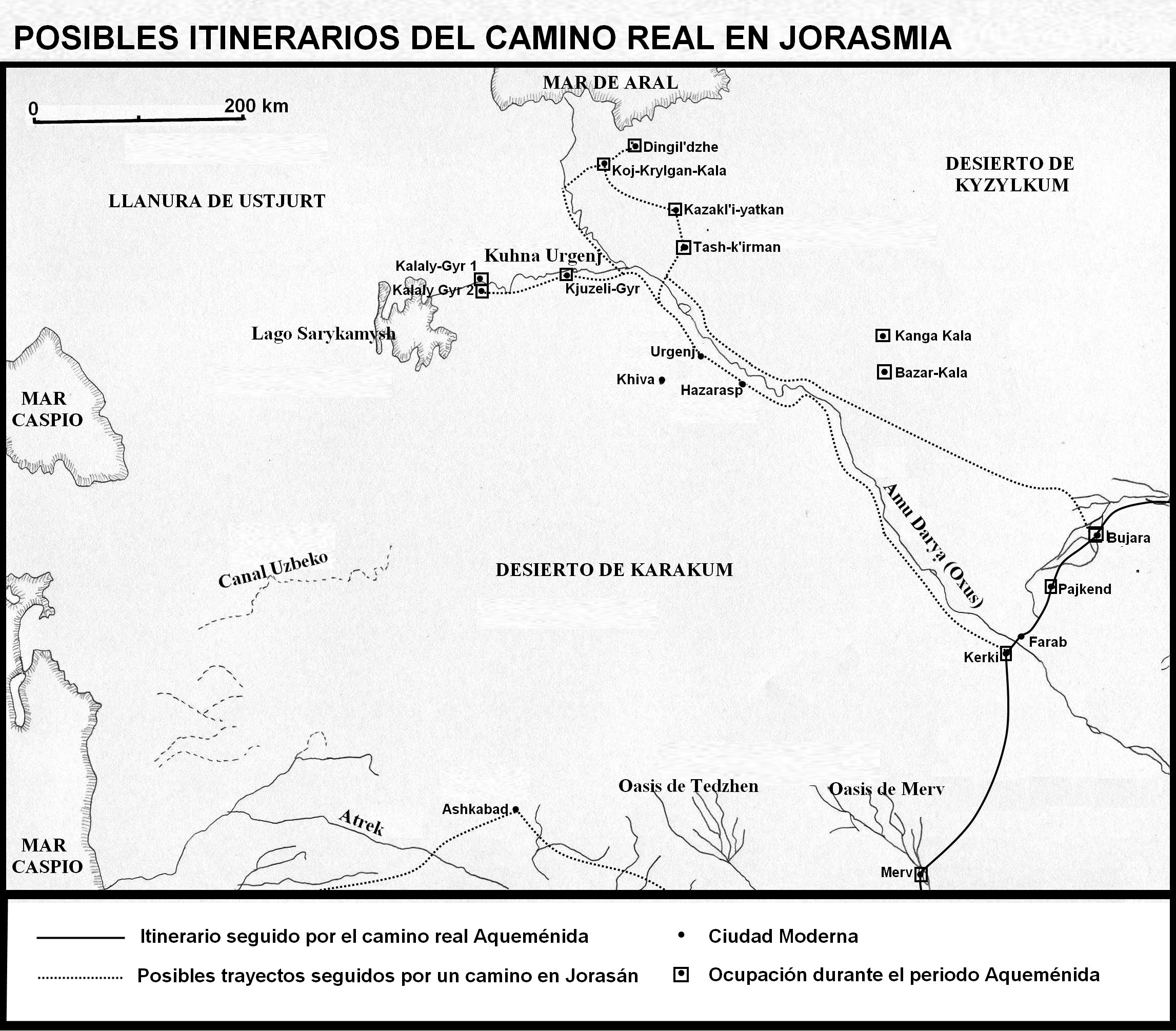
Nor can it be ruled out that two other roads could lead to the vicinity of the Aral Sea, where numerous establishments have been found that show a level of occupation in the Achaemenid period (see the map entitled “Posibles itinerarios del camino real en Jorasmia”). A path could follow the course of the Oxus River from Kerki. Thus, in the lower reaches of this river, in the region of Khorasmia, the settlements of Bazar-kala, Kanga-kala, Kjuzeli-Gyr, Kalaly-Gyr I, Kalaly-Gyr II, Tash-K’irman, Kazakl’yatkan, Koj-Krylgan-Kala and Dingil ‘dzhe have been found. As regards Bazar-kala, the presence of a fortified site has been documented, with a rectangular plan, dating from the IVth century BC. At Kanga-kala, a fortification with a geometric plan has been found dating from the same time as the previous settlement.
In Kjuzeli-Gyr a similar wall has been discovered, in a gallery, although of a rather irregular layout, giving the fortress an almost triangular plan, extending from north to south at a distance of approximately one kilometre. In the middle of the fortress a large building was found, the main room of which covered an area of 285 m2. Three tower-shaped structures were erected in the vicinity of this construction. To the south of the site, another complex of buildings was discovered. Furthermore, the bricks used for the fortress walls were rectangular during the first phase of construction and square during the second; Embrasures were placed every 2 meters, while the towers were built at a distance of about 32 to 36 meters (these towers were oval in the first construction phase and rectangular in the second). These quadrangular forms would support its validity during the Achaemenid period. The pottery discovered at this site has been linked to that of the Yaz III period (500-400 BC), as well as a series of trilobed arrowheads that would support the dating of this period.
As for Kalaly-Gyr I, it is a square-shaped place, covering an area of about 1000 x 700 meters, with a gallery defense and semi-circular towers, with a barbican to protect the entrance; Furthermore, a palace has been identified, with a kind of hypostyle room, with bell-shaped or with bull column bases on a tiered plinth, reminiscent of the Persepolis constructions, although few intramural buildings have been discovered. Kalaly-Gyr II is a place with a triangular plan, dating from the IVth century BC, which also had a gallery defense and a barbican; In addition, pottery of Persian origin has been found, as in Khumbuz-tepe, where in the latter place black pottery characteristic of western Iran and the eastern Caucasus has also been discovered. At Tash-K’irman, fortifications have been found and the presence of a sanctuary was taken into account; the ongoing excavations on the surface of the entire oasis bearing the same name as this establishment will give much more information about the importance of the region during the Achaemenid period. With regard to Kazakl’yatkan, a fortification with a geometric plan has also been found, dating from the IVth century BC; It has a citadel and what seems to be an ancient temple, where the same type of columns have been found as in Kalaly-Gyr I, so it could be a palace, although the ongoing excavations will give more information about this site and about the whole of the establishment. At Koj-Krylgan-Kala a small circular site dating from the IVth century BC was excavated, which appears to be a large mausoleum. As for Dingil ‘dzhe, this small site appears to have been an agricultural and wine-growing “estate”, fact that has provided the excavation with abundant economic information about the site.
Other sites have been found in the lower reaches of the Yaxartes, such as Ujgarak, Balandy, Dzhety-Asar, Chirik-Rabat and Babish-Mulla (See the map entitled “Posibles itinerarios del camino real en Jorasmia”). The latter site, a well fortified place, apparently, in its first phase, during the Achaemenid period, functioned as a satrapal residence given its monumental architecture. It had a large building, known as “Great House”, as well as a plan that unquestionably recalls that of the Persian palaces and that of Ai Khanum, with an open courtyard and peripheral corridors with a defensive wall. With regard to Balandy, a large palatial-type building has been found, although the excavators do not give more information on the possible function of this enclosure. In Chirik-Rabat, a site with a circular plan, the presence of monumental architecture dating from the Achaemenid period is also noted. These findings would confirm the Achaemenid presence in these areas of the Aral Sea, so it cannot be ruled out that a royal road would reach them since the entire Achaemenid imperial space seems to have been covered by this enormous network of roads. ■
BIBLIOGRAPHY
- BADER, P. CALLIERI, T. KHODZHANIYAZOV (1995), “SURVEY OF THE ANTIOCHUS WALL. PRELIMINARY REPORT ON THE 1993-1994 CAMPAIGNS”, IN A. GUBAEV, GA KOSHELENKO & M. TOSI (EDS.), THE ARCHAEOLOGICAL MAP OF THE MURGHAB DELTA. PRELIMINARY REPORTS 1990-1995, ROME, PP. 159-186.
- BENVENISTE (1943-1945), “LA VILLE DE CYRESCHATA”, JOURNAL ASIATIQUE 234, PP. 163-166.
- BERNARD (1996), “L’AORNOS BACTRIEN ET L ‘AORNOS INDIEN. PHILOSTRATE ET TAXILA: GÉOGRAPHIE, MYTHE, ET RÉALITÉ”, TOPOI, ORIENT-OCCIDENT, 6/2, PP. 475 -530.
- B. BOSWORTH, (1980), A HISTORICAL COMMENTARY ON ARRIAN’s HISTORY OF ALEXANDER, VOL. I; COMMENTARY ON BOOKS IV-V, VOL. 2, OXFORD.
- P. FRANKFURT (2005), “ASIE CENTRALE”, IN P. BRIANT, & R. BOUCHARLAT (EDS.), L’ARCHÉOLOGIE DE L ‘EMPIRE ACHÉMÉNIDE. NOUVELLES RECHERCHES, PARIS, PP. 313-352.
- P. FRANKFURT (1979), LES FORTIFICATIONS IN ASIE CENTRALE DE L’ÁGE DU BRONZE ʻA L’ÉPOQUE KOUCHANE, PARIS.
- GEIGER (1882), OSTIRANISCHE KULTUR IM ALTERTHUM, ERLANGEN.
- GENITO, (1998B), “TRIAL-TRENCH AT SITE Nº.215”, IN A. GUBAEV, G. A. KOSHELENKO & M. Tosi, (EDS.), THE ARCHAEOLOGICAL MAP OF THE MURGHAB DELTA. PRELIMINARY REPORTS 1990-1995, ROME, PP. 125-135.
- F. GRAF (1994), “THE PERSIAN ROYAL ROAD SYSTEM”, ACHAEMENID HISTORY 8, PP. 167-189.
- W. HELMS, V. N. YAGODIN (1997), “EXCAVATIONS AT KAZAKL’l · YATKAN IN THE TASH · l · K’IRMAN OASIS OF ANCIENT CHORASMIA: A PREMLIMINARY REPORT”, IRAN 35, PP. 43- 65.
- W. HELMS, V. N. YAGODIN, A. V.G. BETTS, G. KHOZHANIYAZOV, & R. G. KENT, (1953), 0LD PERSIAN: GRAMMAR, TEXTS, LEXICON, II EDITION, REVISED, NEW HAVEN.
- KIDD (2001), “FIVE SEASONS OF EXCAVATIONS IN THE TASH · K’IRMAN OASIS OF ANCIENT CHORASMIA, 1996-2000. AN INTERIM REPORT”, IRAN 39, PP. 119-144.
- W. HELMS, V. N. YAGODIN, A. V.G. BETTS, G. KHOZHANIYAZOV & M. NEGUS (2002). “THE KARAKALPAK-AUSTRALIAN EXCAVATION IN ANCIENT CHORASMIA: THE NORTHERN FRONTIER OF THE CIVILIZED ANCIENT WORLD”, ANCIENT NEAR EASTERN STUDIES 39, PP. 3-44.
- LECOQ (1997). LES INSCRIPTIONS DE LA PERSE ACHÉMÉNIDE, PARIS.
- MARKWART (1946). “DIE SOGDIANA DES PTOLEMAIOS”, ORIENTALIA 15, PP. 286-288.
- NAVEH, J. & SHAKED, SH. (UNPUBLISHED), ARAMAIC DOCUMENTS FROM ANCIENT BACTRIA (FOURTH CENTURY B.C.E.) (CORPUS INSCRIPTIONUM IRANICARUM 1 .5.2), LONDON.
- V. P’YANKOV (1993), “CYROPOLIS”, IN ENCYCLOPAEDIA IRANICA.
- A. RAPAPORT & M.S. LAPIROV · SKOBILO (1963), “FOUILES DANS LE BÁTIMENT PALATIAL DE KALALY · GYR I IN 1958”, MATERIALY KHOREZMKOJ EKSPEDICII, VOL. VI, PP. 141 142.
- l. SARIANIDI (1985). “MONUMENTAL ARCHITECTURE OF BACTRIA”, IN J. L. HUOT, M. YON & Y. CALVET (EDS.), DE L’INDUS AUX BALKANS, PARIS, PP. 417-432.
- SEIBERT (1985), DIE EROBERUNG DES PERSERREICHES DURCH ALEXANDER DEN GROSSEN AUF KARTOGRAPHISCHER GRUNDLAGE (TAVO 68), WIESBADEN, VOL. I (TEXT); VOL. II (MAPS).
- V. SHISHKINA (1994), “ANCIENT SAMARKAND: CAPITAL OF SOGHD”, BULLETIN OF THE ASIAN INSTITUTE 8, pp. 81-99.
- J. VOGELSANG (1992), THE RISE ANO ORGANIZATION OF THE ACHAEMENID EMPIRE. THE EASTERN IRANIAN EVIDENCE, LEIDEN.